Remote Sensing in Agriculture: Revolutionizing Farming Practices
Agriculture, a cornerstone of human civilization, is constantly evolving to meet the demands of a growing global population. One of the most transformative advancements in recent years has been the application of remote sensing in agriculture. This technology, leveraging satellites, drones, and other platforms, provides farmers with invaluable data and insights that optimize resource management, enhance crop yields, and promote sustainable practices. This article delves into the multifaceted applications of remote sensing in agriculture, exploring its benefits, challenges, and future potential.
Understanding Remote Sensing
At its core, remote sensing involves acquiring information about an object or area without physical contact. In the context of agriculture, this typically involves capturing images and data using sensors mounted on various platforms, such as satellites, aircraft, and unmanned aerial vehicles (UAVs), also known as drones. These sensors detect and measure electromagnetic radiation reflected or emitted from the Earth’s surface, providing data on various parameters, including vegetation health, soil moisture, and surface temperature.
Different types of sensors are used in remote sensing, each sensitive to specific wavelengths of the electromagnetic spectrum. For example, multispectral sensors capture data in multiple bands, allowing for the identification of different vegetation types and stress levels. Hyperspectral sensors, on the other hand, capture data in hundreds of narrow bands, providing a more detailed spectral signature of the target. Thermal sensors measure infrared radiation, which can be used to assess plant water stress and soil moisture content.
Applications of Remote Sensing in Agriculture
Crop Monitoring and Assessment
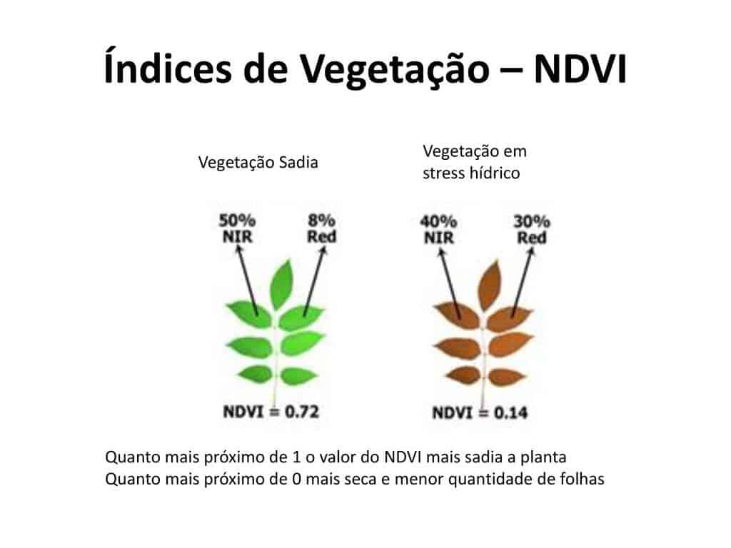
One of the primary applications of remote sensing in agriculture is crop monitoring. By analyzing remotely sensed data, farmers can assess the health and vigor of their crops throughout the growing season. Vegetation indices, such as the Normalized Difference Vegetation Index (NDVI), are commonly used to quantify plant biomass and photosynthetic activity. Changes in NDVI can indicate stress caused by water deficiency, nutrient deficiencies, or pest infestations. Early detection of these issues allows for timely intervention, minimizing yield losses.
Remote sensing also enables precise yield estimation. By correlating remotely sensed data with historical yield data and ground-based measurements, farmers can develop predictive models that accurately estimate crop yields before harvest. This information is crucial for planning storage, marketing, and transportation logistics.
Precision Irrigation Management
Water scarcity is a growing concern in many agricultural regions. Remote sensing in agriculture offers tools for optimizing irrigation practices and conserving water resources. Thermal imagery can be used to map evapotranspiration rates across a field, identifying areas where plants are experiencing water stress. This information allows farmers to implement variable-rate irrigation, applying water only where and when it is needed. By precisely targeting irrigation, farmers can reduce water consumption, improve water use efficiency, and minimize environmental impacts.
Nutrient Management
Nutrient deficiencies can significantly impact crop yields. Remote sensing can help farmers identify areas within a field that are deficient in specific nutrients, such as nitrogen, phosphorus, and potassium. Spectral reflectance patterns are influenced by nutrient content, allowing for the detection of nutrient stress. This information can be used to guide variable-rate fertilizer application, ensuring that crops receive the right amount of nutrients at the right time. Precision nutrient management reduces fertilizer costs, minimizes nutrient runoff, and promotes environmental sustainability.
Pest and Disease Detection
Early detection of pests and diseases is crucial for preventing widespread crop damage. Remote sensing can be used to identify areas within a field that are affected by pests or diseases. Changes in plant spectral reflectance, caused by pest infestations or disease infections, can be detected using remotely sensed data. Early detection allows for targeted application of pesticides or other control measures, minimizing the use of chemicals and reducing environmental impacts. Furthermore, understanding the spatial distribution of pests and diseases can help farmers implement more effective integrated pest management strategies.
Soil Mapping and Analysis
Soil properties play a critical role in crop productivity. Remote sensing can be used to map and analyze soil characteristics, such as soil moisture content, organic matter content, and salinity levels. Radar remote sensing is particularly useful for mapping soil moisture, as microwaves are sensitive to water content. Spectral reflectance data can be used to estimate soil organic matter content, which is a key indicator of soil health. Mapping soil salinity is important in arid and semi-arid regions, where salt accumulation can reduce crop yields. Soil maps generated from remotely sensed data can be used to guide soil management practices, such as tillage, fertilization, and irrigation.
Yield Prediction and Crop Insurance
Accurate yield prediction is essential for crop insurance purposes. Remote sensing data integrated with machine learning models provides robust yield prediction capabilities. By analyzing various factors like plant health, environmental conditions and historical data, insurance companies can assess potential losses more accurately and provide better risk management solutions to farmers. Remote sensing in agriculture allows for more efficient and reliable crop insurance assessments.
Benefits of Remote Sensing in Agriculture
- Improved Resource Management: Remote sensing enables farmers to optimize the use of water, fertilizers, and pesticides, reducing input costs and minimizing environmental impacts.
- Enhanced Crop Yields: By detecting and addressing crop stress early on, remote sensing helps farmers maximize crop yields and improve overall productivity.
- Sustainable Practices: Remote sensing in agriculture promotes sustainable farming practices by reducing resource consumption, minimizing environmental pollution, and enhancing soil health.
- Cost Savings: Precision agriculture techniques, enabled by remote sensing, can reduce input costs and improve profitability.
- Data-Driven Decision Making: Remote sensing provides farmers with valuable data and insights that support informed decision-making.
- Scalability: Remote sensing solutions can be scaled to cover large areas, making them suitable for both smallholder farmers and large-scale agricultural operations.
Challenges and Limitations
Despite its numerous benefits, remote sensing in agriculture also faces certain challenges and limitations:
- Data Availability and Cost: The cost of acquiring high-resolution satellite imagery and drone data can be prohibitive for some farmers.
- Data Processing and Analysis: Processing and analyzing remotely sensed data requires specialized expertise and software.
- Cloud Cover: Cloud cover can interfere with the acquisition of optical imagery, limiting the availability of data in some regions.
- Calibration and Validation: Remotely sensed data must be calibrated and validated with ground-based measurements to ensure accuracy.
- Integration with Existing Systems: Integrating remote sensing data with existing farm management systems can be challenging.
The Future of Remote Sensing in Agriculture
The future of remote sensing in agriculture is bright, with ongoing advancements in sensor technology, data analytics, and artificial intelligence. Emerging trends include:
- Increased use of drones: Drones are becoming increasingly affordable and accessible, allowing farmers to collect high-resolution data on demand.
- Integration of AI and machine learning: AI and machine learning algorithms are being used to automate data processing and analysis, making remote sensing more accessible to farmers.
- Development of new sensors: New sensors are being developed to measure a wider range of parameters, such as plant disease severity and soil nutrient levels.
- Improved data fusion: Combining data from multiple sources, such as satellites, drones, and ground-based sensors, can provide a more comprehensive picture of crop health and soil conditions.
- Edge computing: Processing data on the edge, closer to the source, can reduce latency and improve real-time decision-making.
As technology continues to evolve, remote sensing in agriculture will play an increasingly important role in ensuring food security, promoting sustainable practices, and enhancing the resilience of agricultural systems. Farmers who embrace these technologies will be well-positioned to meet the challenges of a changing world. [See also: Precision Agriculture Techniques] and [See also: Sustainable Farming Practices]
The convergence of remote sensing in agriculture with other technologies like IoT (Internet of Things) and big data analytics will further propel the industry forward. Real-time data from soil sensors, weather stations, and other sources can be integrated with remotely sensed data to create a holistic view of the farm. This integrated approach allows for more precise and timely interventions, optimizing resource allocation and maximizing yields. As the cost of these technologies decreases and their accessibility increases, more farmers will be able to leverage the power of remote sensing in agriculture to improve their operations.
In conclusion, remote sensing in agriculture is transforming the way we grow food. By providing farmers with valuable data and insights, this technology enables more efficient resource management, enhanced crop yields, and sustainable practices. While challenges remain, the future of remote sensing in agriculture is promising, with ongoing advancements paving the way for a more resilient and productive agricultural sector.
